16th Jan 2026 Technology
Hydrographic surveys and bathymetric surveys
Hydrographic surveys play a critical role in understanding submerged environments that cannot be reliably measured by traditional terrestrial techniques alone.
Hydrographic surveys play a critical role in understanding submerged environments that cannot be reliably measured by traditional terrestrial techniques alone.
At Academy Geomatics Ltd, we’ve developed our hydrographic survey capability to deliver high-confidence bathymetric survey data for reservoirs, rivers, canals, lagoons and engineered water bodies across the UK. These assets often underpin critical infrastructure, water supply, flood management and environmental protection, making accurate underwater data essential.
A bathymetric survey is fundamentally concerned with measuring the shape, depth and character of the submerged bed. However, a bathymetric survey should not be confused with a hydrographic survey.
While the two terms are frequently used interchangeably, they represent different aspects of underwater measurement, and the distinction is important when specifying scope, accuracy and deliverables.
In simple terms, a bathymetric survey is the output, whereas a hydrographic survey is the professional process used to produce it.
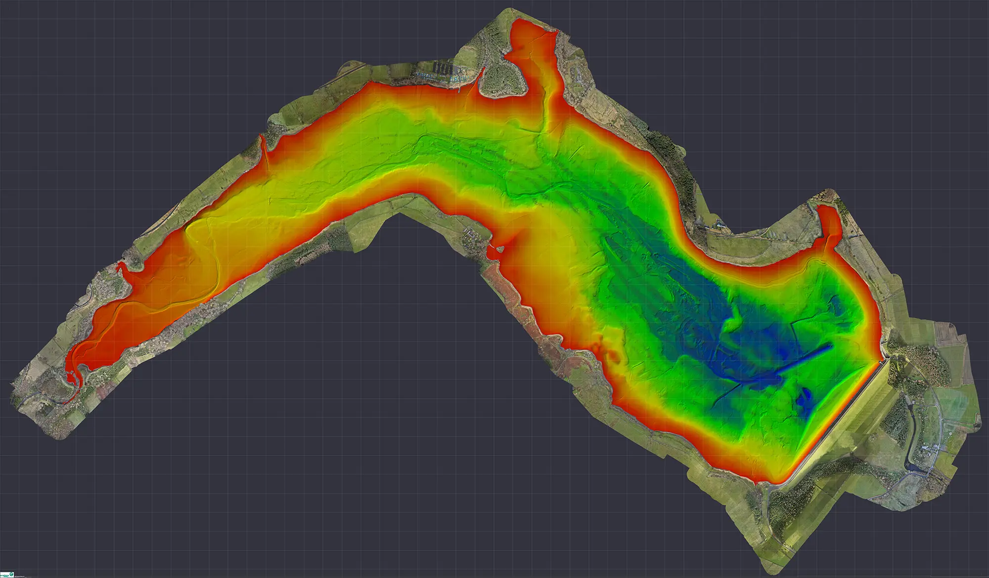
A bathymetric survey focuses on the end result: a mapped model of underwater depths, levels, slopes and volumes. The deliverables from a bathymetric survey typically include digital terrain models, contours, sections and volume calculations that describe the submerged surface.
A hydrographic survey, by contrast, is the discipline and methodology that governs how underwater data is collected, controlled and verified. It encompasses survey planning, GNSS positioning, motion compensation, echo sounder selection, sound velocity correction, quality assurance and reporting.
A hydrographic survey ensures that the bathymetric survey data is accurate, repeatable and defensible. Without a properly controlled hydrographic survey, bathymetric survey outputs may lack reliability, particularly where decisions involve safety, capital investment or regulatory compliance.
A hydrographic survey is the measurement and mapping of underwater features using specialist acoustic, positioning and motion-compensation systems. In most engineering and infrastructure contexts, the hydrographic survey is commissioned specifically to support a bathymetric survey, producing a digital representation of the submerged bed and side slopes.
Unlike visual inspection or inferred depth measurements, a professional hydrographic survey captures direct, georeferenced measurements of depth, slope, sediment condition and bedform geometry. This information is essential for reservoir capacity assessments, siltation studies, dam safety reviews, structural inspections of embankments and long-term asset management.
A high-quality hydrographic survey provides the technical framework that allows bathymetric surveys to be repeated over time, enabling meaningful comparison and change detection.
A bathymetric survey is the mapped representation of the underwater environment produced from hydrographic survey data. It describes the geometry of the submerged bed, including hard bed and soft sediment surfaces, slopes, scours and other features.
Bathymetric surveys are commonly used to:
The reliability of a bathymetric survey depends entirely on the quality of the hydrographic survey used to generate it.
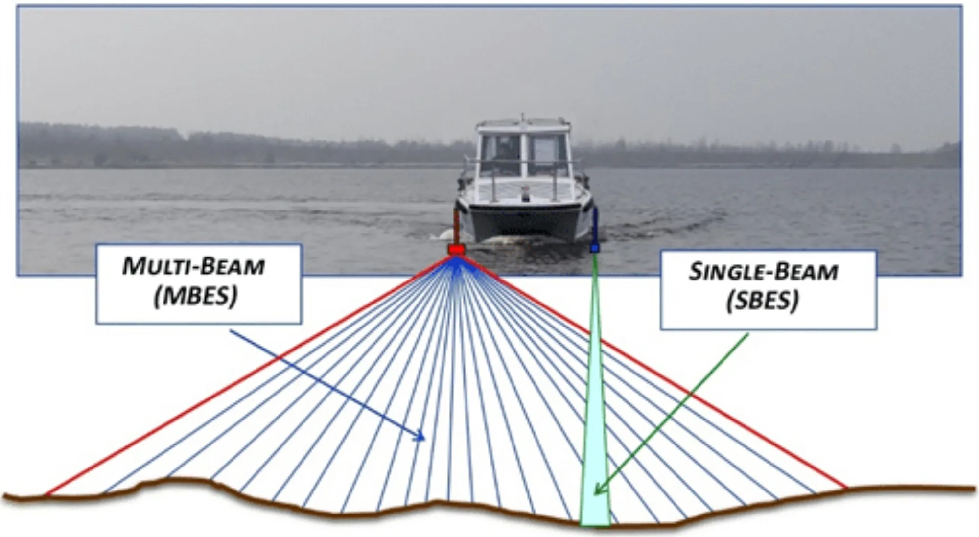
Single Beam Echo Sounder (SBES) bathymetric surveys measure depth at a single point directly beneath the survey vessel. SBES systems are robust and well suited to targeted profiling, verification checks and hard bed detection using appropriate frequencies.
However, SBES bathymetric surveys provide limited spatial coverage and can miss critical features between survey lines.
Multibeam Echo Sounder (MBES) bathymetric surveys represent best practice for modern hydrographic survey projects. MBES systems emit a fan of acoustic beams, capturing thousands of depth measurements per second and delivering full-coverage bathymetric survey data with high point density.
This allows accurate modelling of slopes, scours, deformation and sediment distribution across the entire submerged area.
Many bathymetric surveys require differentiation between accumulated soft sediment and the underlying hard bed. Academy Geomatics combines MBES bathymetric survey data with targeted SBES techniques to identify both surfaces where conditions allow.
Manual probing to refusal is used where required to verify acoustic interpretation, providing confidence in hard bed levels and sediment thickness.
Bathymetric LiDAR plays an important role in shallow water and shoreline zones where vessel-based hydrographic survey methods are inefficient or impractical. It bridges the gap between terrestrial LiDAR and acoustic bathymetric survey data, improving continuity at the land–water interface.
Bathymetric LiDAR does not replace hydrographic surveys but complements them, enhancing overall dataset completeness.
All hydrographic surveys undertaken by Academy Geomatics are tied to robust GNSS-derived survey control networks. This ensures bathymetric survey data integrates seamlessly with topographical surveys, UAV LiDAR, terrestrial laser scanning and engineering design datasets.
Verification procedures include cross-comparison of SBES and MBES data, review of multibeam backscatter, manual depth checks and independent processing quality assurance. All verification and limitations are clearly documented within the factual hydrographic survey report.
Typical hydrographic and bathymetric survey deliverables include:
Hydrographic and bathymetric surveys underpin informed decision-making wherever submerged assets, water bodies and hydraulic infrastructure are concerned. Accurate underwater data is essential for safety, regulatory compliance, effective asset management and long-term planning.
Understanding the distinction between hydrographic surveys as the controlled measurement process and bathymetric surveys as the mapped output ensures that survey scope, accuracy and deliverables are correctly specified from the outset.
The experienced Academy Geomatics team combines proven hydrographic survey methodology with advanced bathymetric survey technologies to deliver high-confidence datasets across the UK.
Our integrated approach brings together MBES for full-coverage mapping, SBES for targeted verification, hard and soft bed interpretation, bathymetric LiDAR integration and robust GNSS control. This ensures that every dataset is accurate, repeatable and fully defensible.
Whether supporting reservoir safety reviews, sediment assessments, infrastructure inspection, or long-term monitoring, our surveys are designed to stand up to engineering, environmental and regulatory scrutiny.
To discuss your hydrographic or bathymetric survey requirements, or to explore how Academy Geomatics can support your project, get in touch with our team today.

For more information about our geospatial services, or to commission a survey or discuss a project, please get in touch.